The Heads of the department: corresponding member of the AS of the Kazakh SSR Bezsonov A.I. (1939-1945); Dr. Geo. Sc., Sokolov S.I. (1946-1951); Cand.Ag. Sc., SR Petelina A.M. (1951-1956); Cand. Ag. Sc., SR Storozhenko D.M. (1956-1968); Cand. Ag. Sc., SR Kolkhodzhayev M.K. (1968-1970); Corresponding Member of the AS of the Kazakh SSR Uspanov U.U. (1971-1977); Cand.Ag. Sc., SR EvstifeyevYu.G. (1977-1990); Cand.Ag.Sc., SR Abdykhalykov S.D. (1990-1995); Dr.Bio.Sc. Davlyatshin I.D. (1995-1996); Cand.Bio.Sc. Pachikin K.M. from 1996 to present
At different stages of the development of soil research in the Republic, in accordance with the R&D topic, the laboratory was called:
1939-1945 – soil sector;
1946-1956 – department of soil geography;
1956-1977 – department of soil geography and genesis;
1977-1990 – laboratory of soil geography and cartography;
1991-1995 – laboratory of soil genesis, geography and classification;
1995 to the present - department of soil geography, genesis and assessment.
In 1946-1956 along with the department of soil geography, there was an independent
department of soil genesis (headed by Cand. Geo.Sc., JR Glazovskaya M.A.; Dr.Geo.Sc. Sokolov S.I.) and in 1966-1977 – Department of Soil Cartography (Head, Cand.of Ag. Sc., SR Yevstifeyev Yu.G.). Subsequently, they were abolished and merged with the basic department of soil geography.
During its existence, 4 Doctoral and 27 Candidate theses have been defended in the department.
Currently, the department consists of 8 people, including 4 candidates of sciences and 4 young employees:
Main research areas
-study of spatial patterns of soil surface formation;
-detection of soil morphogenetic features, their genetic essence;
-development of soil classification and taxonomy;
- study of soil geographic-genetic and zonal-provincial features and soil surface;
- conducting soil-cartographic works based on GIS technologies using space information materials;
-assessment of current state of soils and soil surface in the context of increasing anthropogenic impact on ecosystems.
Services provided by the department:
- assessment of current state of soil surface and creating soil and thematic maps (soil maps of various scales, degradation maps, maps of agro-industrial soil grouping) with subsequent recommendations on soil use, placement of agricultural crops, and measures to improve them.
Main achievements
The department staff carried out the following researches on the State programs and projects:
"Soils of mountains and foothill plains of the Northern Tien Shan and Dzungarian Alatau" in the section "Soils and soil surface of the mountains and foothill plains and intermountain valleys of the Northern Tien Shan", 1981-1985.
"Create regional soil maps of the territory of Kazakhstan" in the section "Creation of a soil map of southeastern Kazakhstan (Semirechensky polygon)", 1986-1990.
"Studies of soil geographic-genetic and zonal-provincial specifics and soil surface of desert zone and mountainous regions of Kazakhstan", 1991-1993. In the same period, joint work was carried out with Chinese soil scientists on the topic: "Soil-geographic research of arid territories of Kazakhstan and the XUAR (PRC) and development of measures on their rational use and protection."
"Genetic features and impact of soils on biodiversity of Kazakhstan" in the section "Geographic and genetic features of classification of soils and soil surface of the desert zone and mountainous regions of Kazakhstan", 1994-1996.
“Soils and soil surface of Kazakhstan, genetic features, patterns of formation and spread, current state, assessment, rational use and protection”, in the section “Soils and soil surface of South Kazakhstan: genetic features, patterns of formation and spread, current state (on the example of the Zhambyl region)”, 1997-1999.
"Principles of soil surface mapping, research methods of its anthropogenic transformation in the arid regions of Kazakhstan", 2000-2002.
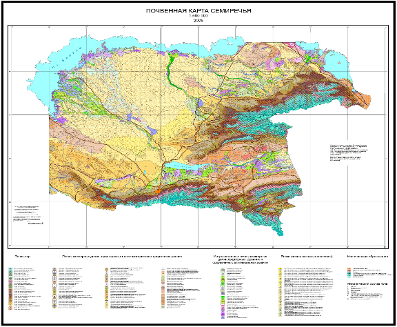
On the basis of field research, satellite imagery materials and using GIS technologies, CD electronic versions of soil maps of Semirechye (Almaty region) and Zhambyl region at a scale of 1: 500,000 were created and published.
Project: "Issues of genesis, fertility and ecology of soils in the mountainous regions of Kazakhstan in terms of anthropogenesis", section "Soil Information System of the South-East of Kazakhstan", 2003-2005.
Project: "Soil information system of Zhambyl region" 2006-2008.
 | |
Soil map of Almaty region | Soil map of Zhambyl region |
Based on the created soil database and soil map, map of soil quality scores was developed. Soil morphogenetic, physicochemical properties of Almaty and Zhambyl regions of Kazakhstan were studied.
Project: “Modern methods of assessing land resources in arid regions of Kazakhstan (on the example of Karaganda region), 2006-2008.
 |  | 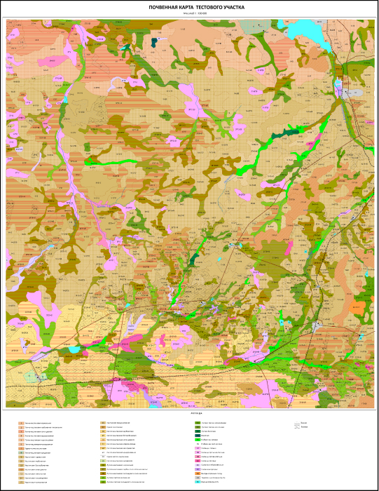 |
Regularities of formation of soils and soil surface of the territory have been studied. A soil map of the project area at a scale of 1:100,000 was made on the basis of satellite imagery and field studies using GIS technologies. The main factors of soil degradation have been identified; criteria for soil disturbance have been developed. A map of the current state of soil surface, a map of soil quality scores, a map of land agro-industrial grouping has been done.Recommendations for rational use of soils have been developed.
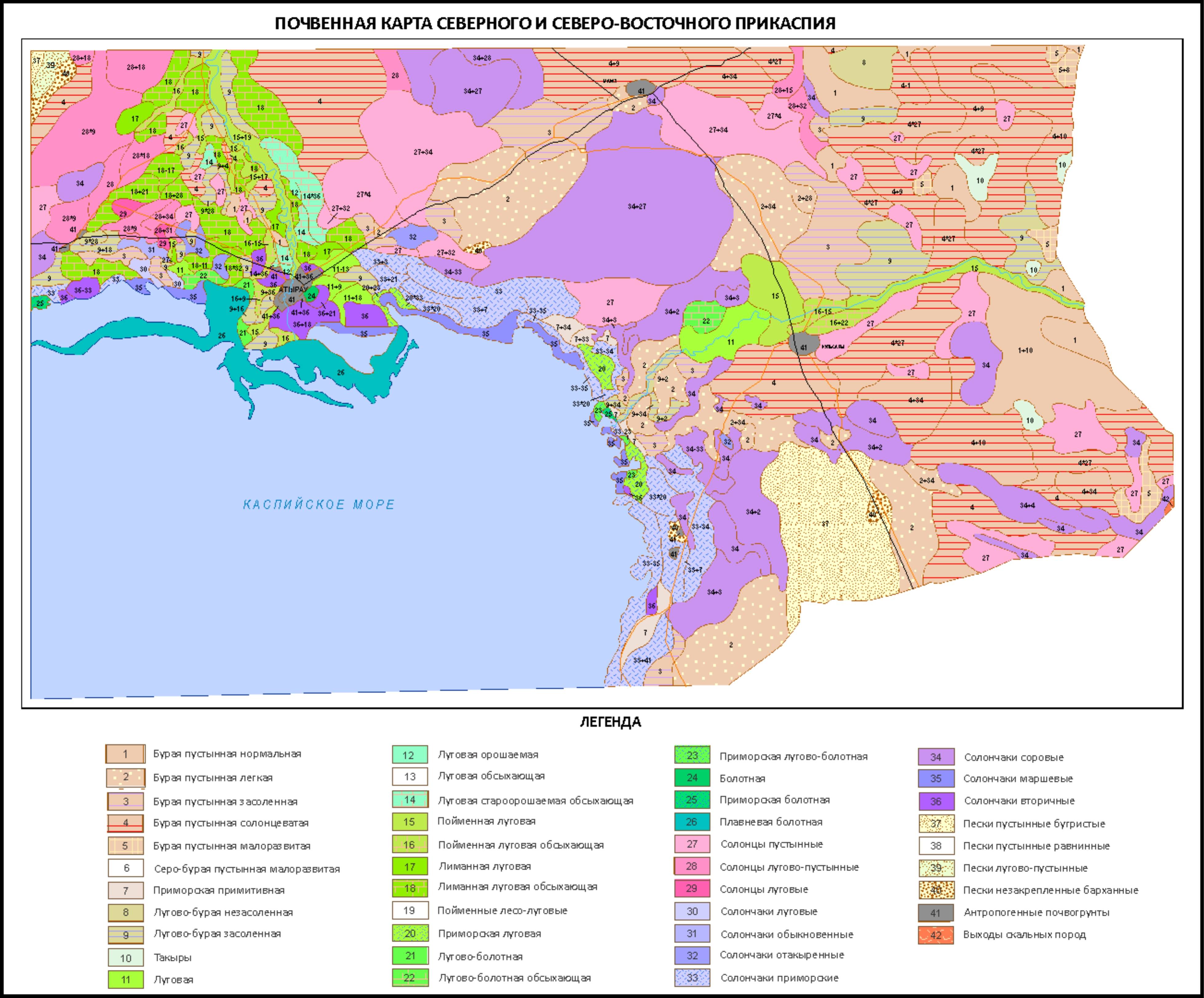
Project: "Assessment of the current state of soil surface of oil-producing regions of the Caspian Sea area"; 2009-2011
Soil maps and maps of soil surface degradation in the Northern and North-Eastern Caspian (1: 500,000) and the test area (1: 10,000) were created based on interpretation of satellite images. Based on soil map and developed scales for assessing soil stability and grading, maps of soil resistance to anthropogenic impacts and quality scores were created.
Project: "Assessment of the current state of agricultural land in southern Kazakhstan", 2009-2011.
The current state of soil surface of the territories of intensive agricultural use in the South Kazakhstan region, including irrigated areas located on the left bank as well as right bank of the ancient alluvial plains of the Syr Darya river, and areas of rainfed agriculture, which are close to the foothill plains of the Western Tien Shan have been studied. As a result of the research, main patterns of soil formation within the selected test plots (3 * 300 thousand ha) were determined, and specifics of soil transformation under anthropogenic impacts were studied.
Based on the research, an electronic version of soil map of South Kazakhstan was compiled at a scale of 1:500 000. Grading scales were created for soil assessment of the territory and a map of soil bonitet scores in the south of Kazakhstan was done. A scheme of natural zoning of the territory has been developed.
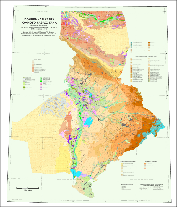
Soil map of South Kazakhstan
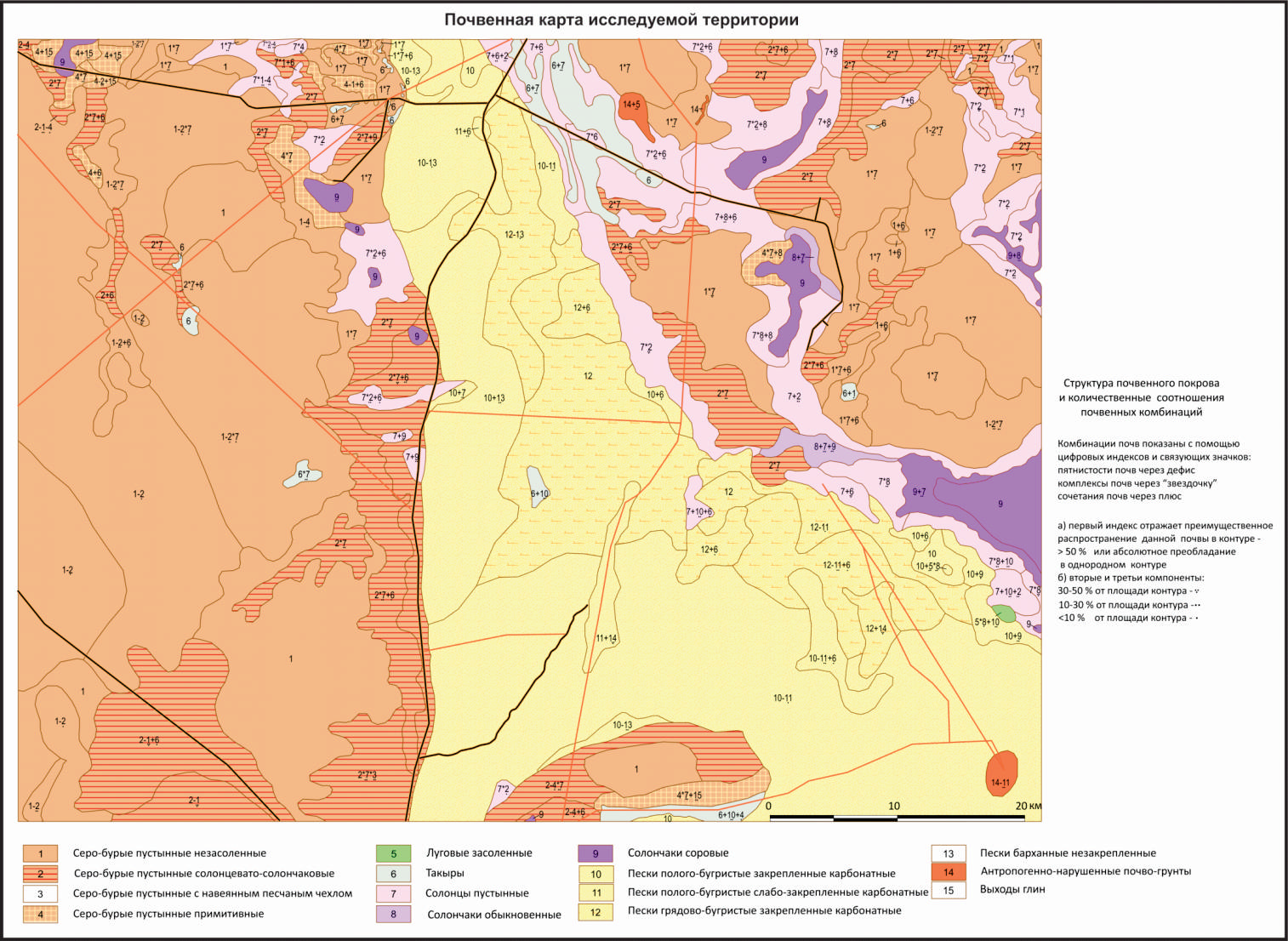
Project: "Assessment of the current state of agricultural lands of the Eastern Aral Sea area"; 2012-2014
The current state of soils of the most typical processes of anthropogenic transformation in agricultural and pasture regions of the North-Eastern Aral Sea region has been studied. Modern electronic versions of soil maps of key areas were created using geoinformation technologies in the MapInfo Professional environment and using satellite imagery and field research data. The principles and methods of mapping soil anthropogenic transformation were developed, taking into account the criteria and factors of soil degradation, and electronic versions of soil degradation maps were created.
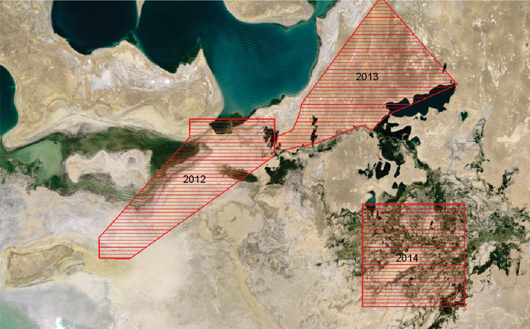
Scheme of site locations
 | 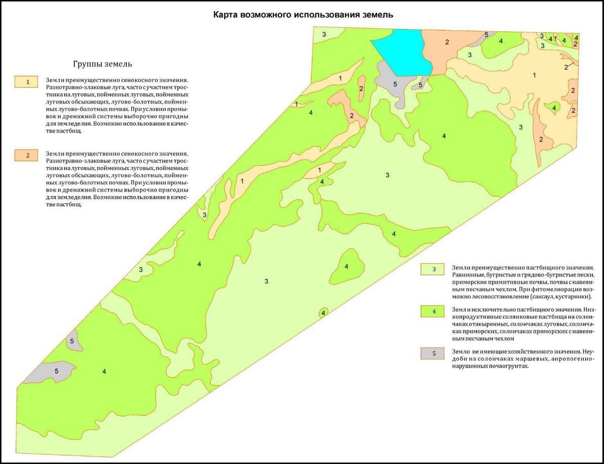 |
Soil map and map of possible use of soils of the part of the dried bottom of the Aral Sea
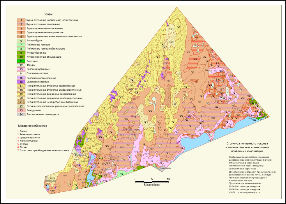 |  |
Soil map and soil surface degradation map of the North-Eastern Aral Sea area
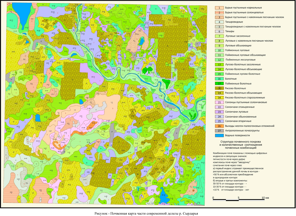 |  |
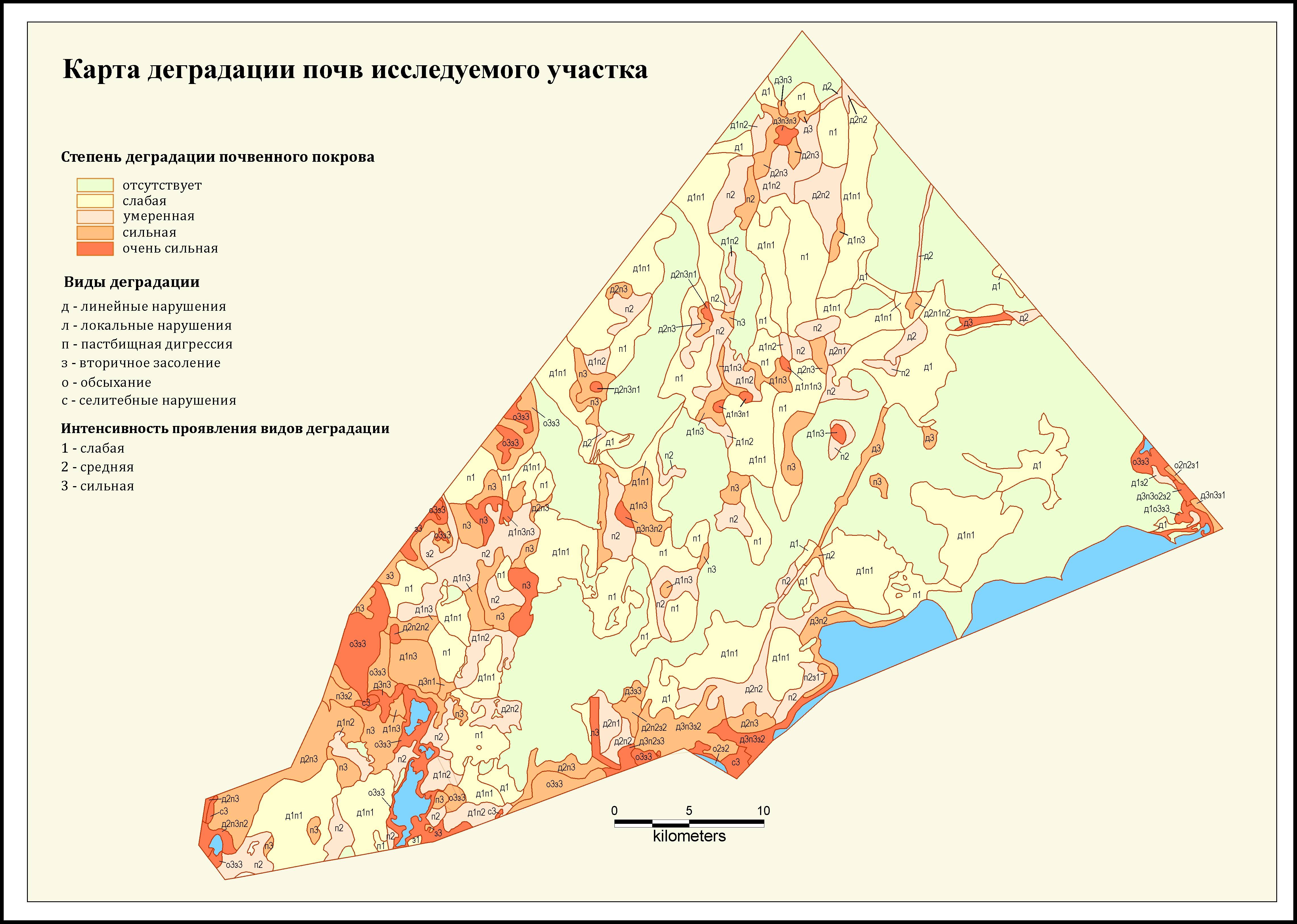
Soil map and map of soil degradation of a part of the modern delta of the Syrdarya river
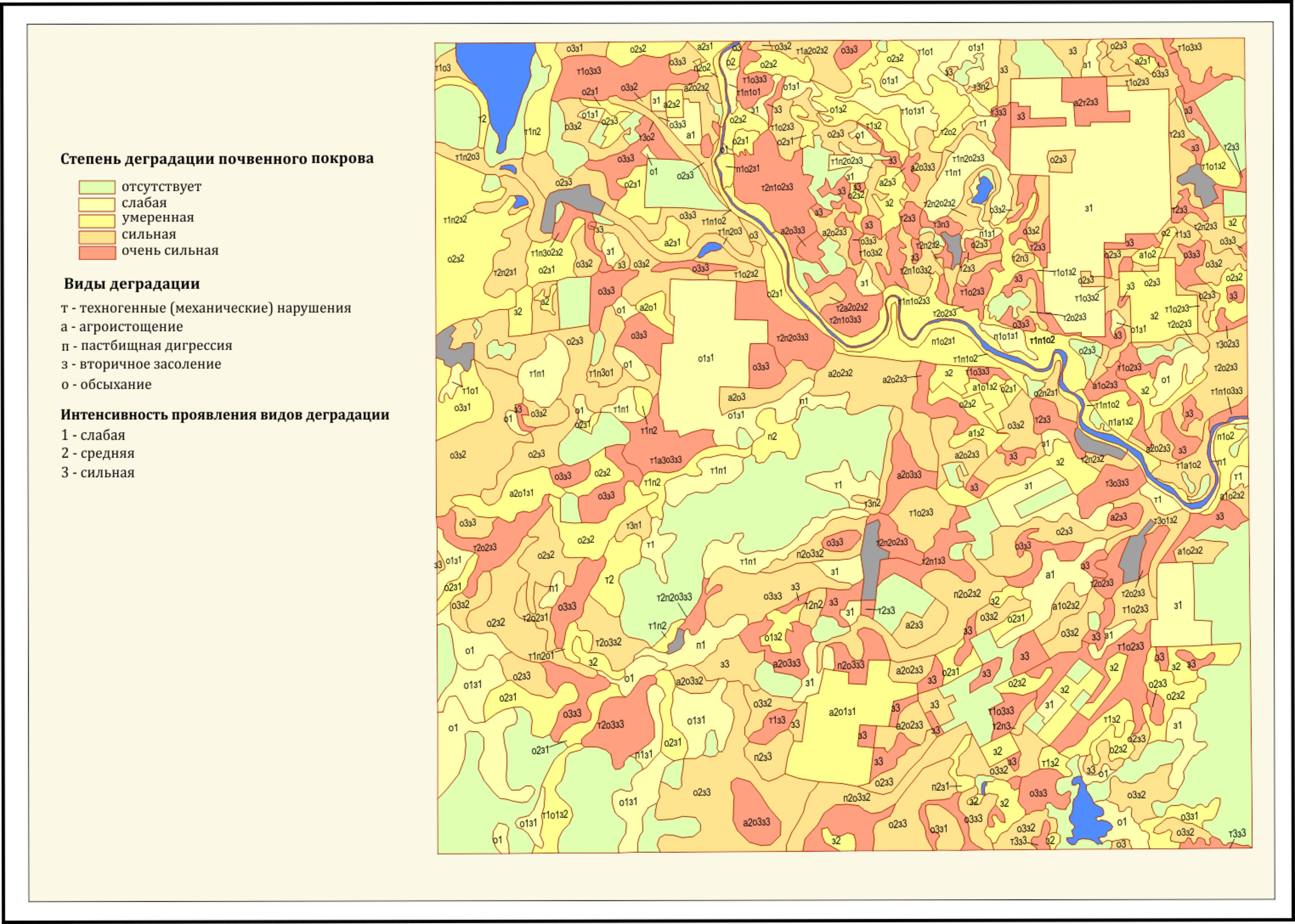
Project: "Assessment of the current state of soil surface of the oil-producing regions of Kyzylorda region, 2012-2014.
Soil morphological and physicochemical properties of the research area were studied, the patterns of formation of soil surface were described, and soil characteristics were presented; route field studies were carried out, soil samples were selected and analyzed to study their morphological and physico-chemical properties and assessment of the degree of degradation of soil surface; a soil map of the experimental site and adjacent territories was created; disturbance criteria have been developed and a map of soil degradation has been drawn up; a grading scale was developed and a map of soil bonitet scores for the study area was done; a scale of soil resistance to various types of anthropogenic impact was developed, maps of soil resistance to mechanical impacts and petrochemical pollution were created.
 Soil map Soil map | 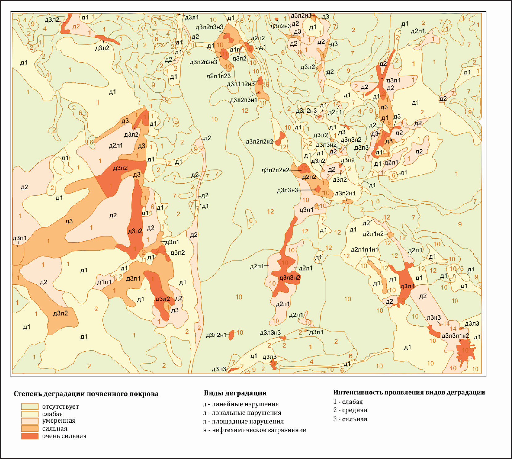 Soil degradation map |
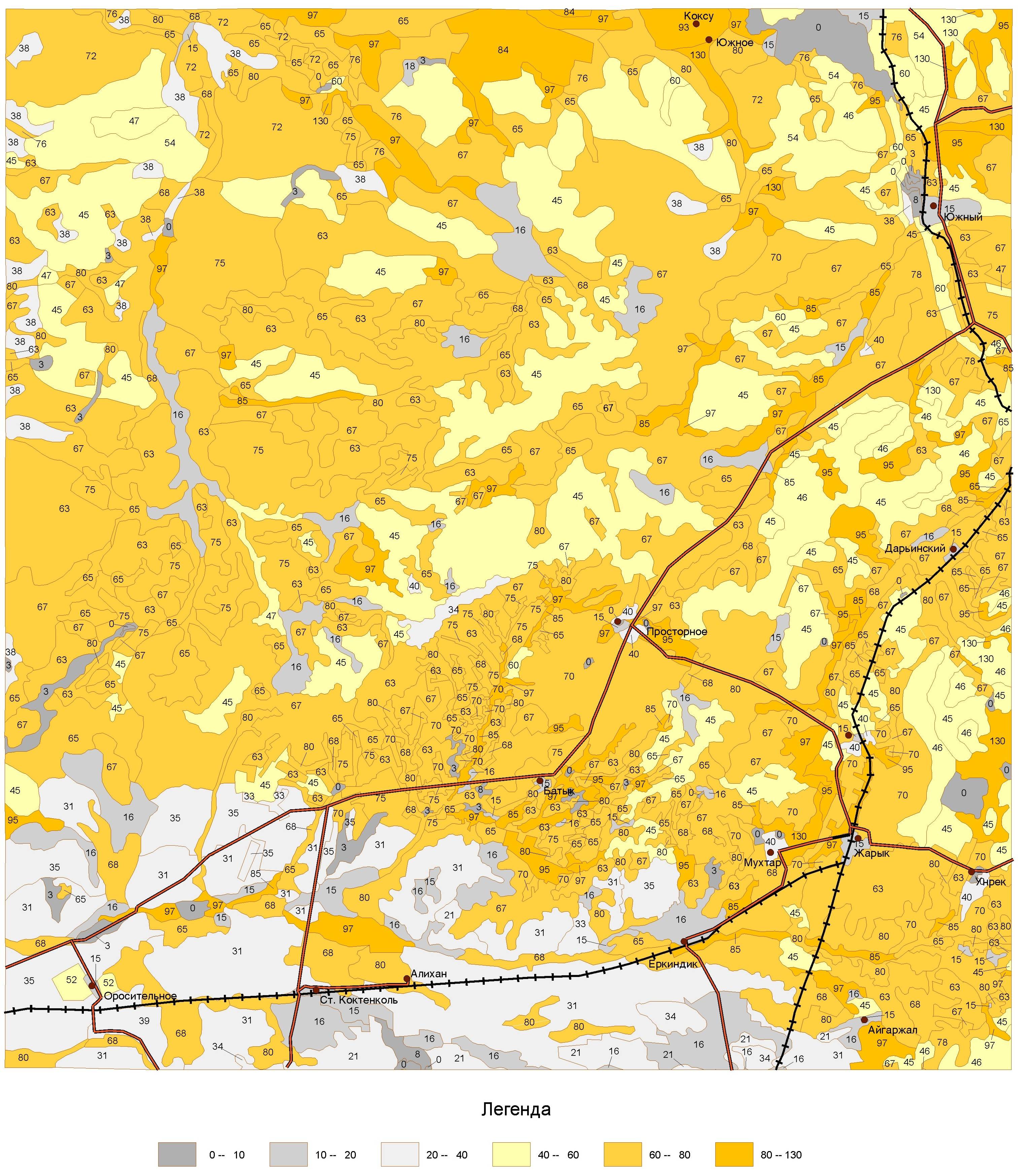
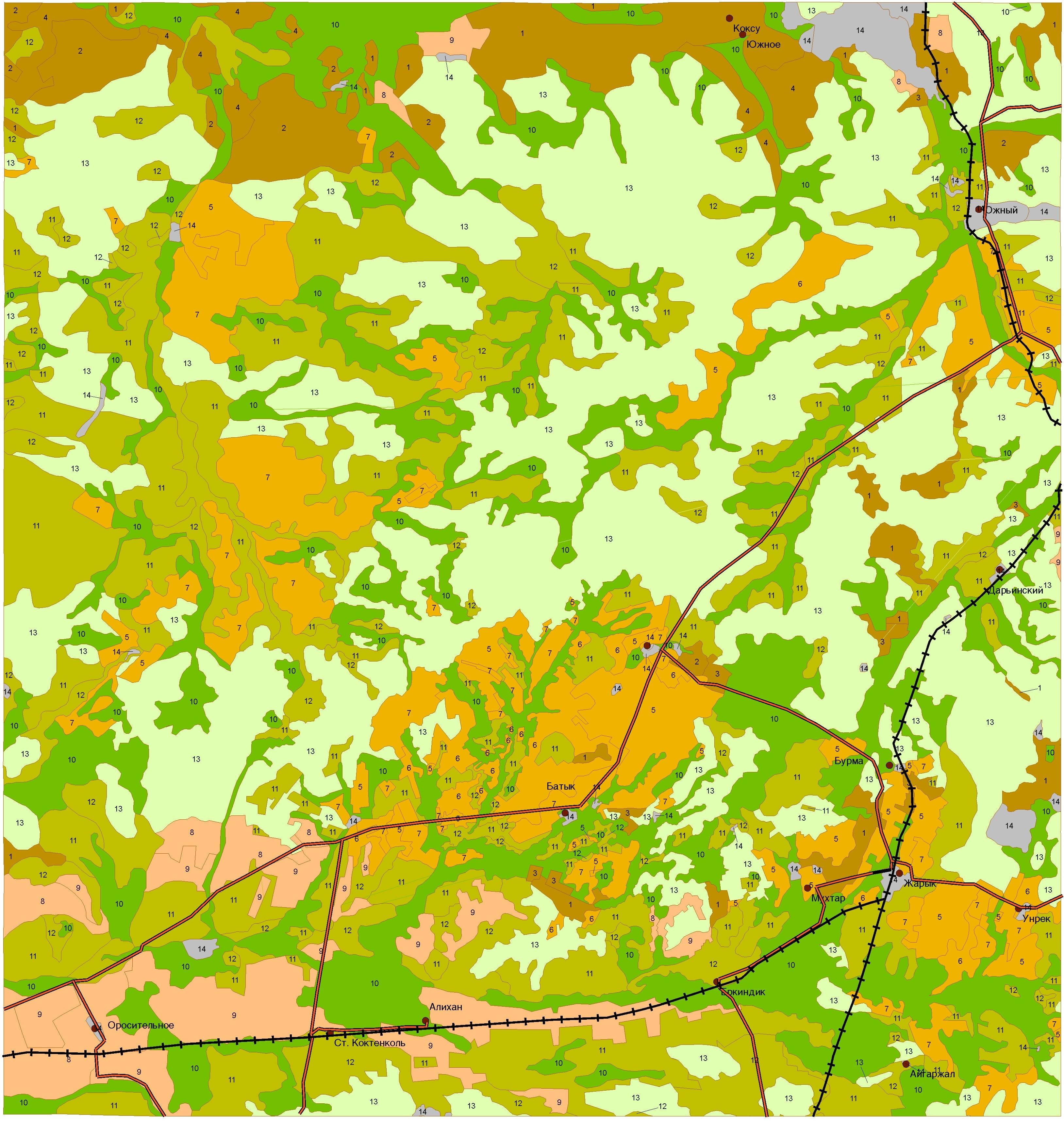
Project: “Spatial modeling of soil erosion in the mountainous and foothill regions of the south-east of Kazakhstan, 2015-2017. (Budget program 055 "Scientific and / or scientific and technical activities"; Priority "Rational use of natural resources, processing of raw materials and products").
The main aim of the project-is to determine potential soil erosion using the USLE methodology within the GIS platform. Based on the available input data, including the use of remote sensing images and a simple interface within GIS, areas at risk from water erosion of soils were identified and erosion risk map was created. The integration of remote sensing results into GIS was performed using the USLE model:
The erosion factor of precipitation (coefficient R) was calculated using geostatistical method – kriging, and mapping of potential impact of precipitation on erosion of the studied soil.
Soil erodibility factor (K coefficient) was calculated on the basis of soil characteristics (organic matter concentration, mechanical composition, soil type).
DEM (digital elevation model) model was built to calculate the LS topographic factor.
The land use factor (coefficient C) was calculated using supervised and unsupervised classification using remote detection, and integrating this factor into the final map.
The final erosion map of the study area was prepared and analyzed with analysis of the spatial distribution of erosion intensity using the USLE model.
Calculations were made and maps were created on transport of microelements with soil substrate in the study area. Microelements studied: zinc (Zn); cadmium (Cd); cobalt (Co); copper (Cu); lead (Pb) and nickel (Ni).
Spatial distribution of topographic factor and average annual soil losses
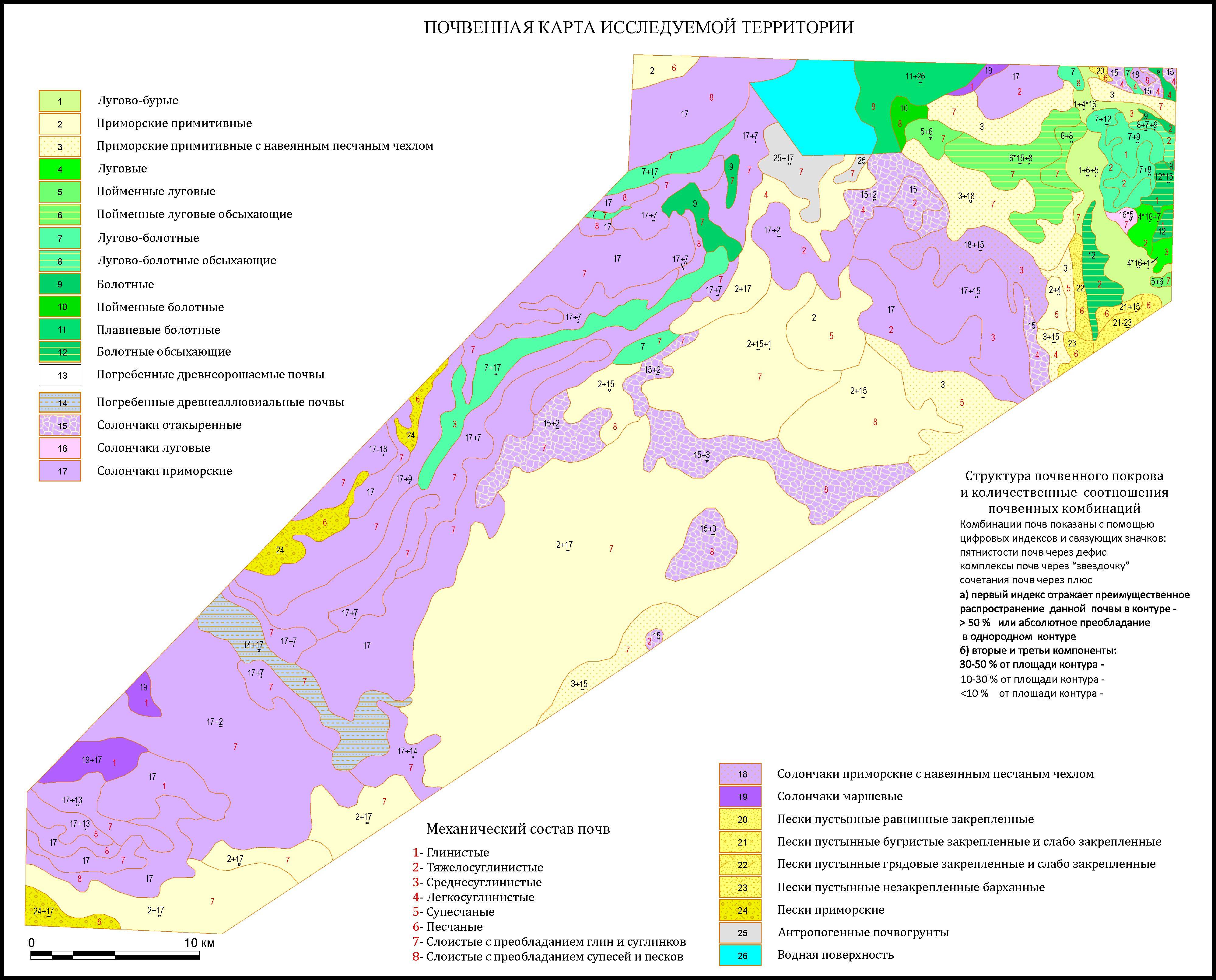
STP O.0683 “Ecological assessment of the state of coastal soils and waters of the Caspian Sea in connection with development of oil fields on the shelf and development of method of biological cleaning of the coastal zone from oil pollution. Project: "Ecological assessment of soilsurface of the coastal zone of the Caspian Sea" 2015-2017.
The research aim: to give a comprehensive assessment of the current state of soil surface of coastal zone of the Caspian Sea; identify soil degradation processes.
The research objects are soils and soil surface of the part of the northern coast of the Caspian Sea, adjacent to the modern delta of the Ural river.
Soil samples were taken as a result of route field studies (384). Within the test area, 81 sections were done, 18 description points. The morphological and physicochemical properties of selected soil samples were studied. The analysis of selected samples was carried out, information was entered into soil database. As a result of processing the obtained materials, a soil map of the northern coast of the Caspian Sea was made within the modern and part of the ancient delta of the Ural river on a scale of 1: 100000. To assess the degree of soil degradation in characterized territory, the main parameters and criteria for assessing soil degradation have been developed. A grading scale has been created. An electronic map of soil degradation in the coastal zone of the Caspian Sea has been created on a scale of 1:100000. A map of quality scores on a scale of 1:100000 has been created.
To assess the degree of soil stability of the characterized territory, the main parameters and criteria for assessing soil stability have been developed. Electronic maps of soil stability in the coastal zone of the Caspian Sea were created at a scale of 1:100 000.
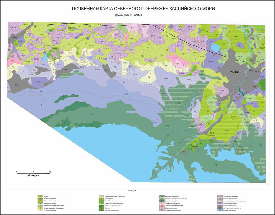 |  |
Soil map and soil degradation map of the coastal zone of the Caspian Sea
STP O.0709: "Preservation and reproduction of soil fertility in Kazakhstan".2015-2017
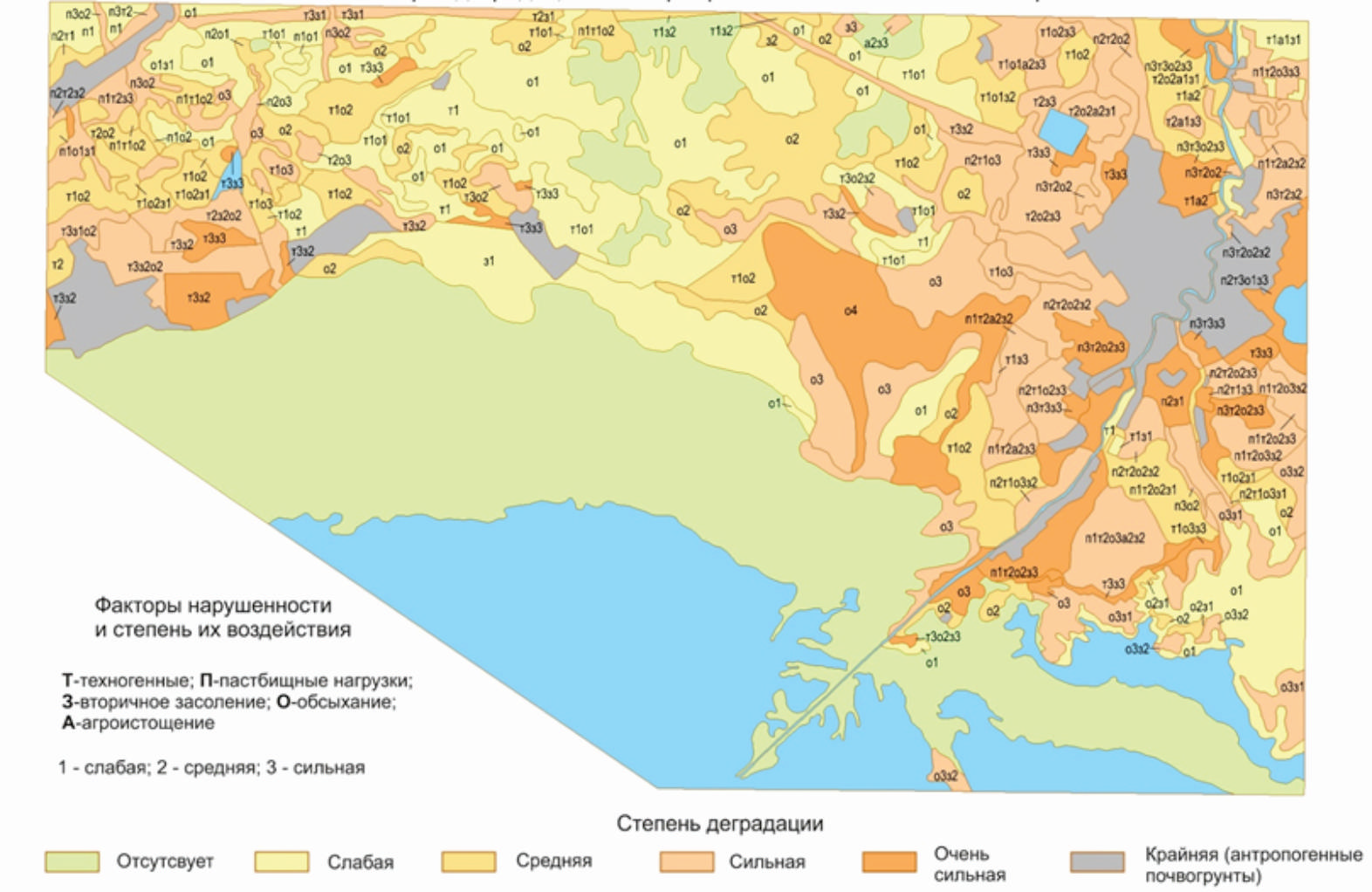
Project: "Assessment of the current state of agricultural lands in southeastern Kazakhstan (on the example of the foothill plains of the Zhetysu Range)". (Budget program 212 "Scientific research and activities in the field of AIC and environmental management")
The current state of soils of the most typical anthropogenic transformation processes in agricultural and pasture regions of the foothill plains of the Zhetysu Range was studied: main physicochemical and morphological properties of virgin soils and soils used in agriculture, processes occurring in soils as a result of anthropogenic factors. Modern electronic versions of soil maps of key areas were created using geoinformation technologies in the
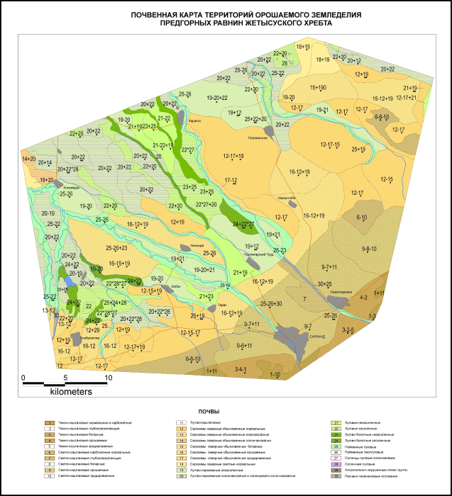 | 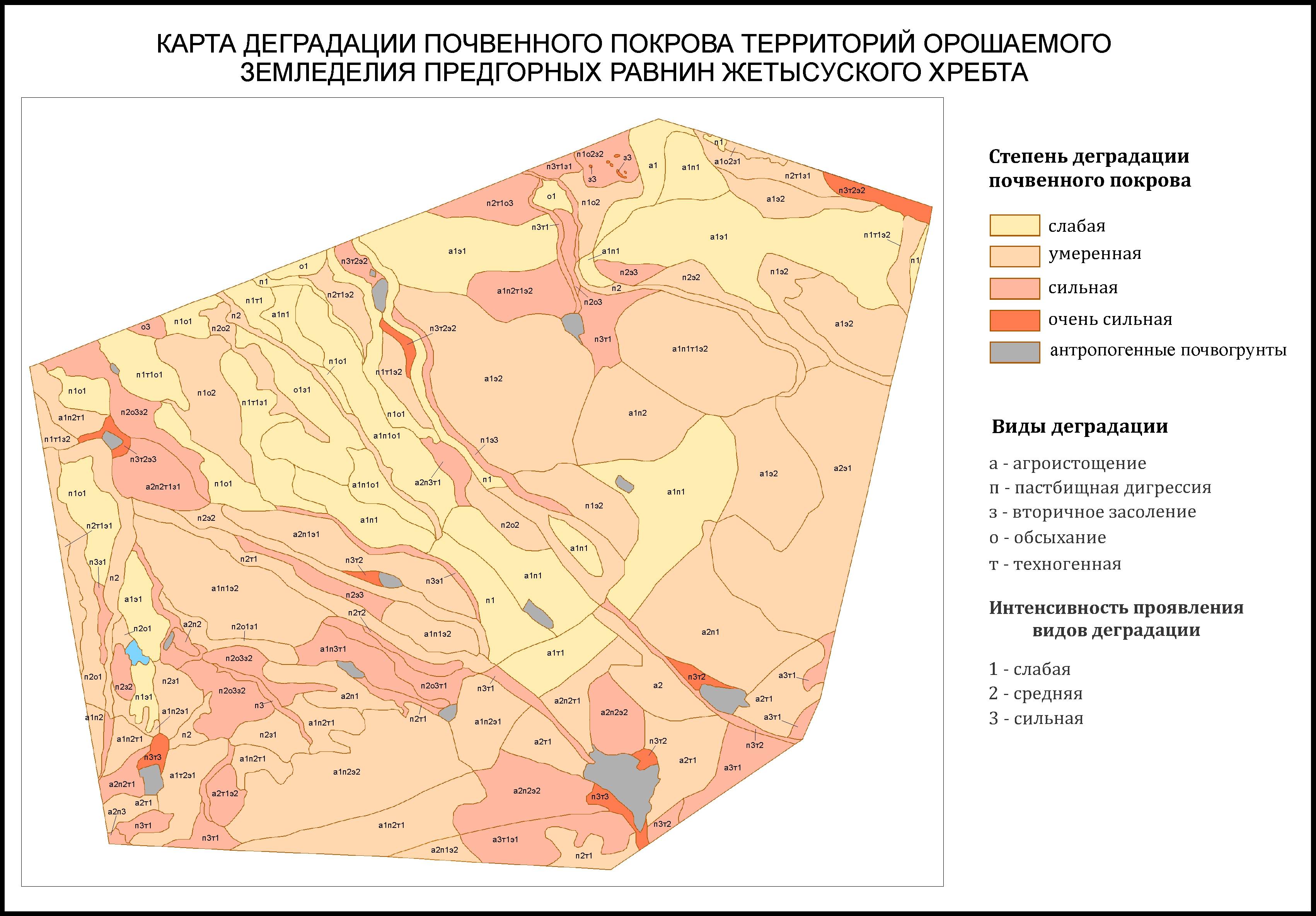 |
MapInfoProfessional environment and using satellite imagery materials and field research data. Applied (soil degradation, agro-industrial grouping of lands) maps of the test area were created on a scale of 1:100 000.
Soil map and map of soil surface degradation in irrigated agriculture areas
of Zhetysu ridge
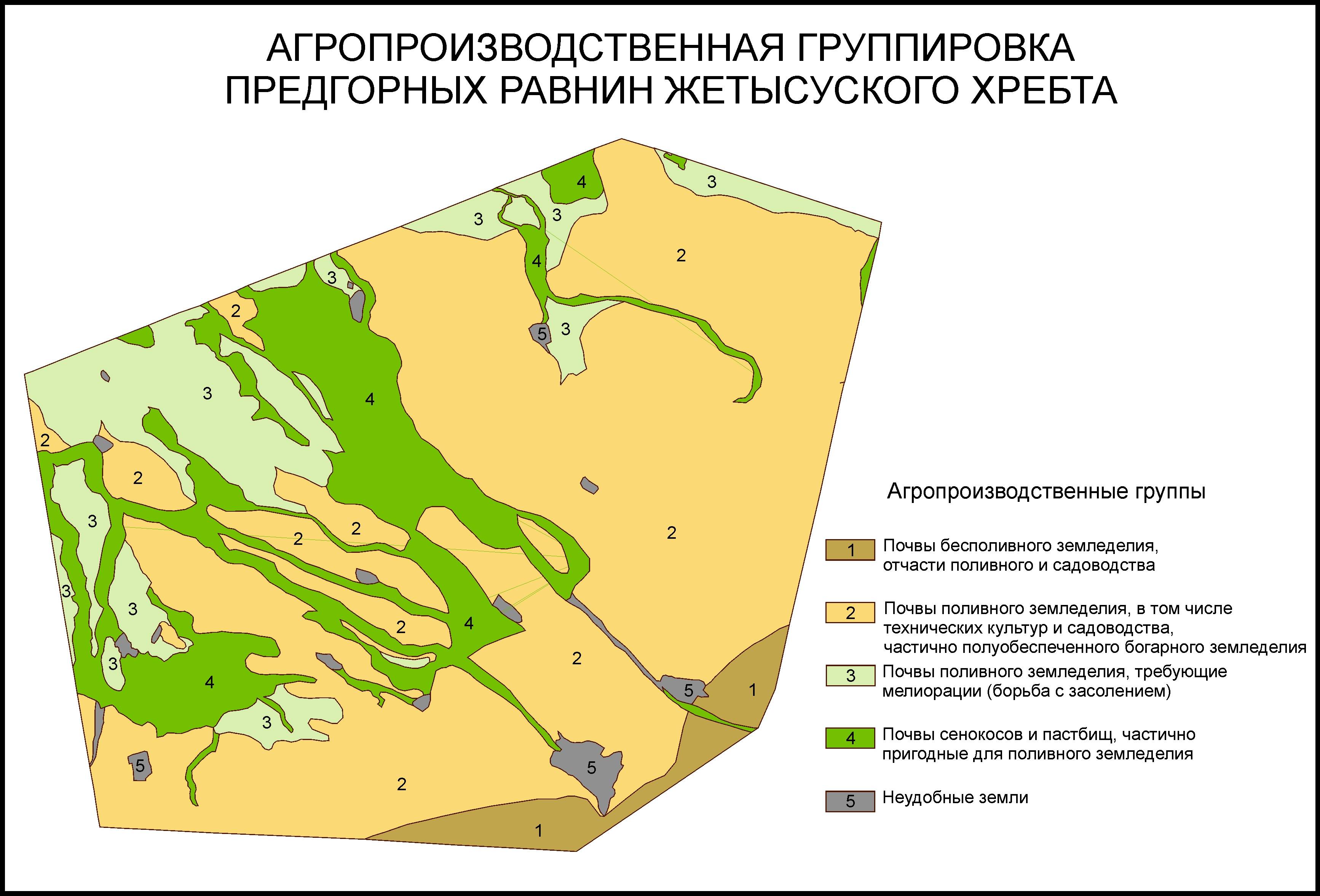
Map of agro-industrial land grouping
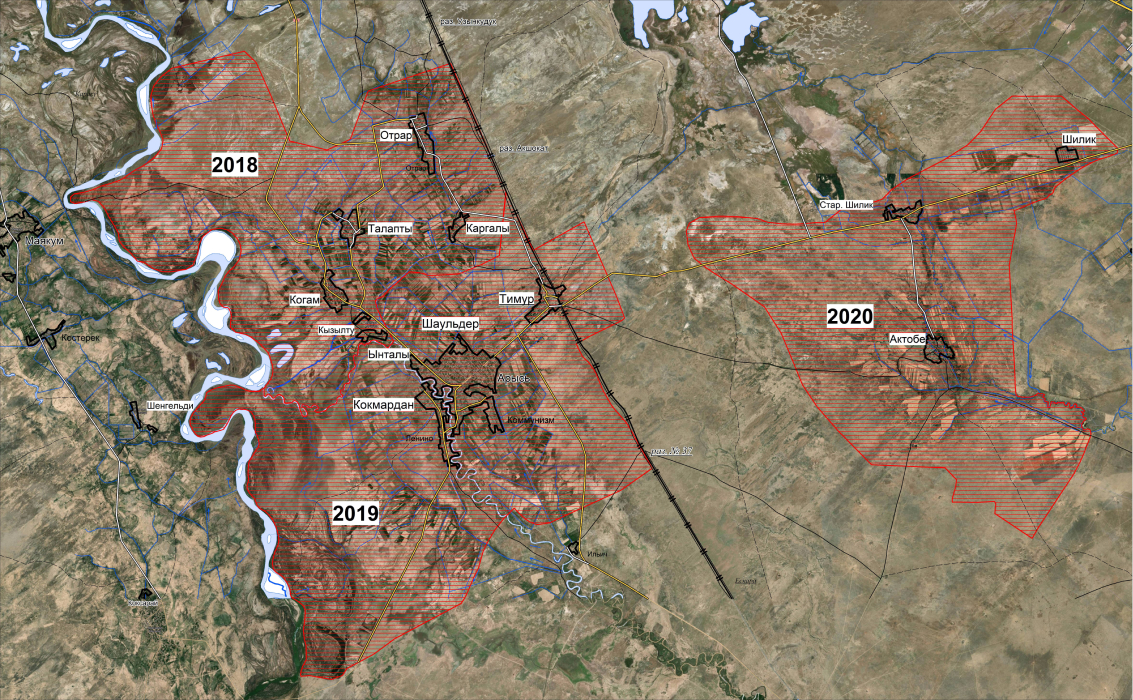
Location of soil cuts and sampling sites of the Shaulder irrigation massif
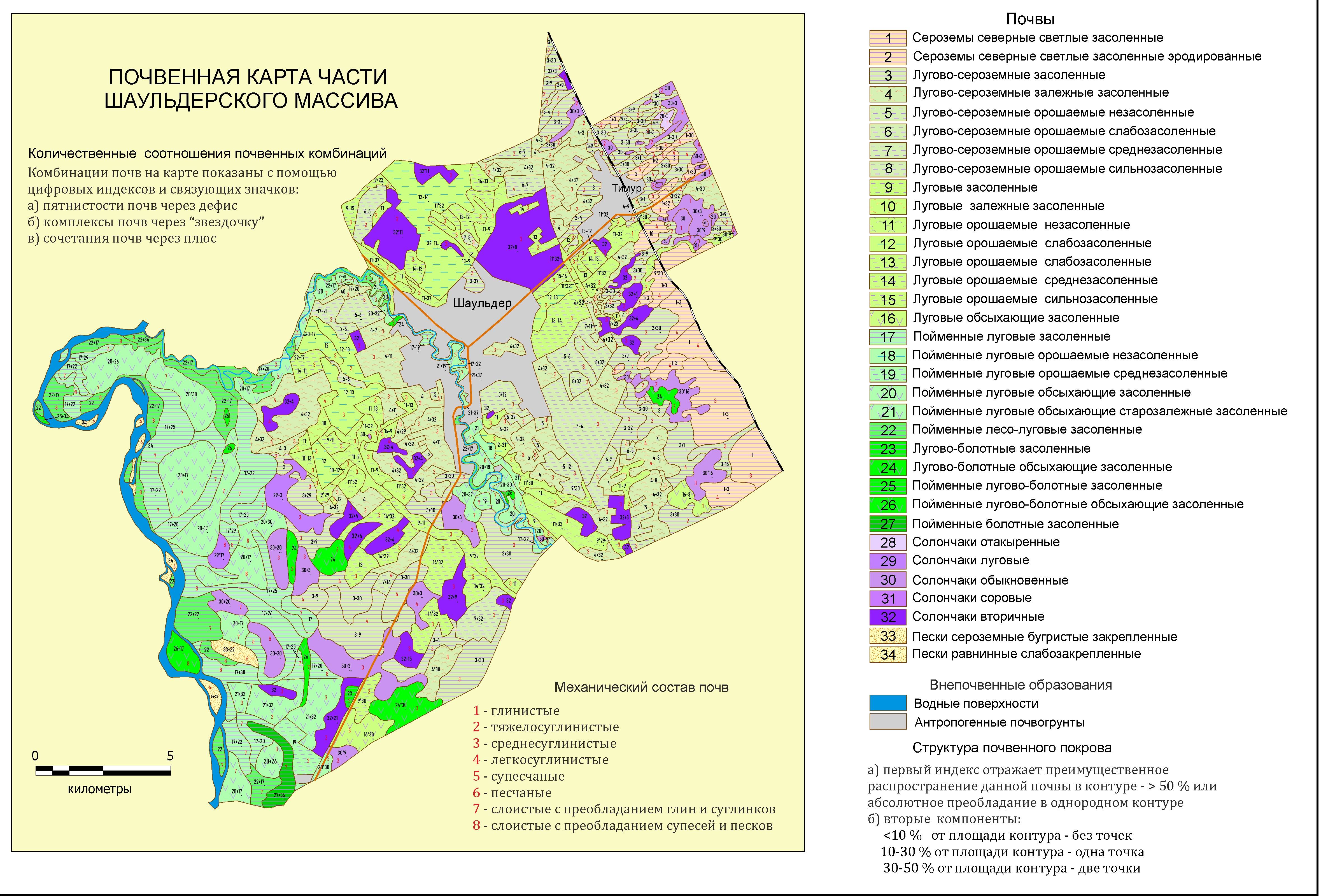 | 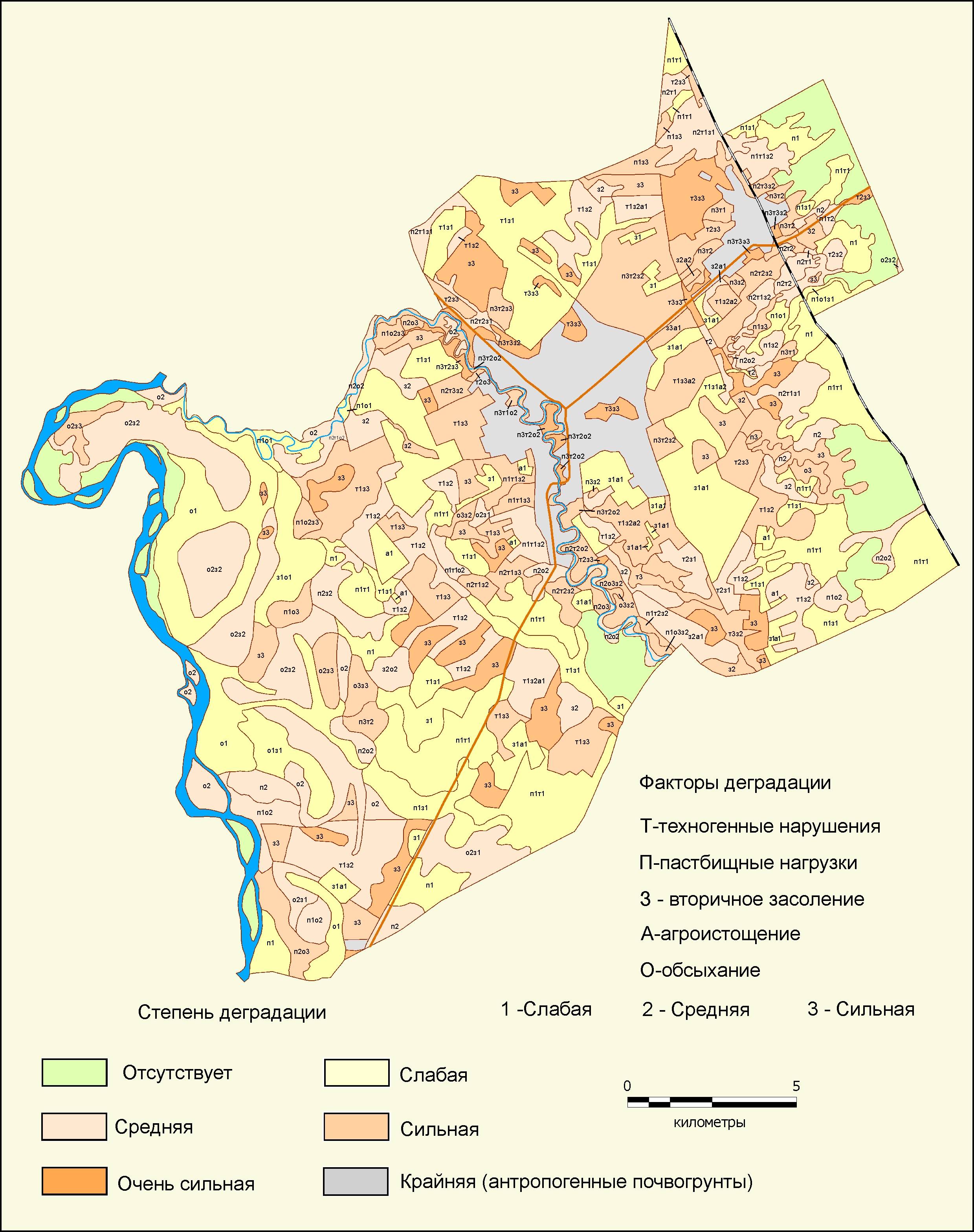 |
Soil map and map of soil degradation in central part of Shaulder massif
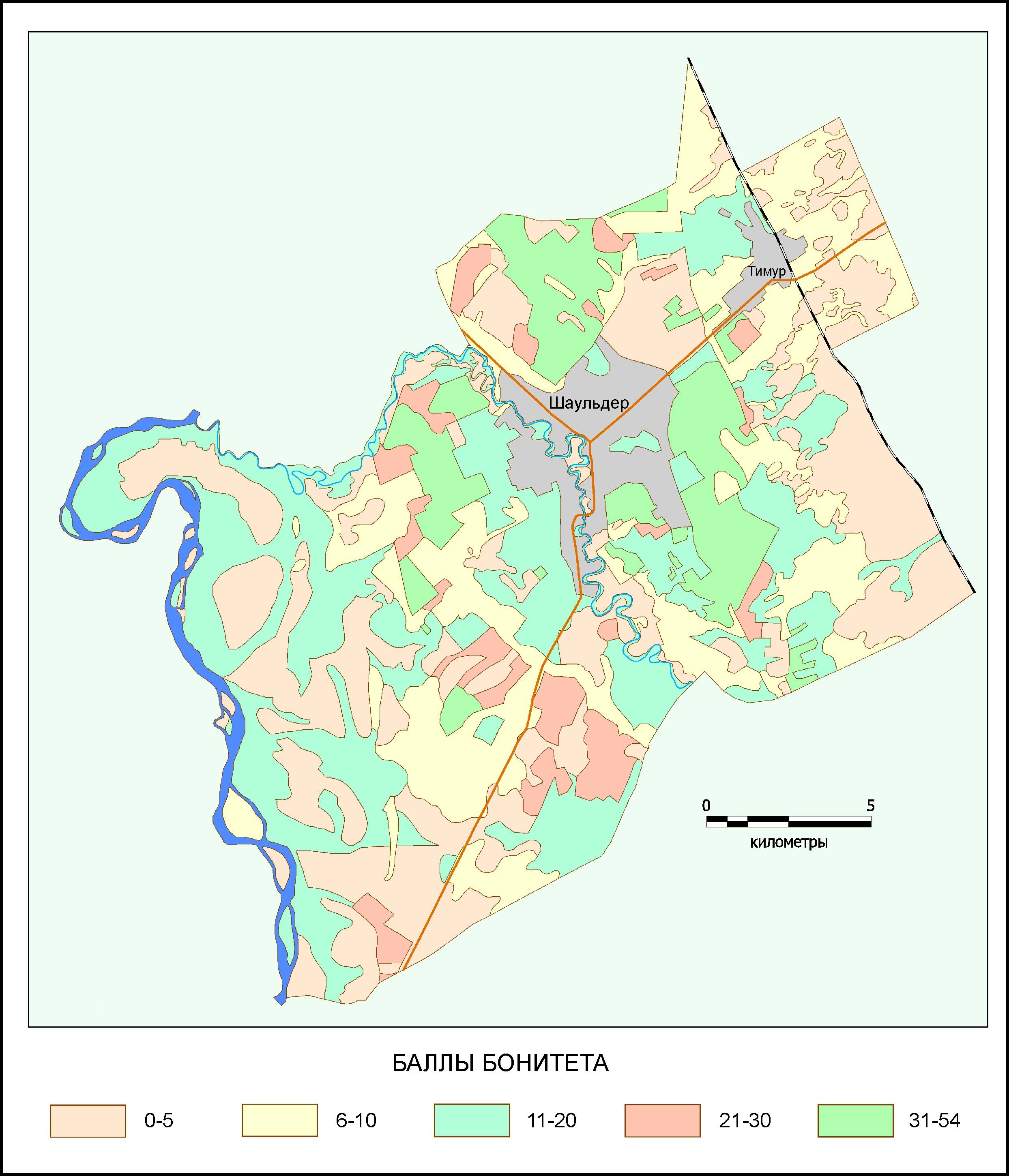
Map of soil quality scores in the central part of the Shaulder massif
STP O.09013 "Creation of innovative agri-technological park for the implementation of precision farming." Block 3. "Introduction of innovative technology to improve soil fertility and crop yields (bioorganic fertilizers)", 2018-2020
In the course of the work, field studies were conducted, soilmorphological, chemical and physicochemical properties were studied, electronic version of the soil map of the OntustikAgropark (scale 1: 25000) was created for an area of 4800 hectares, a structure was developed and a soil database was developed.
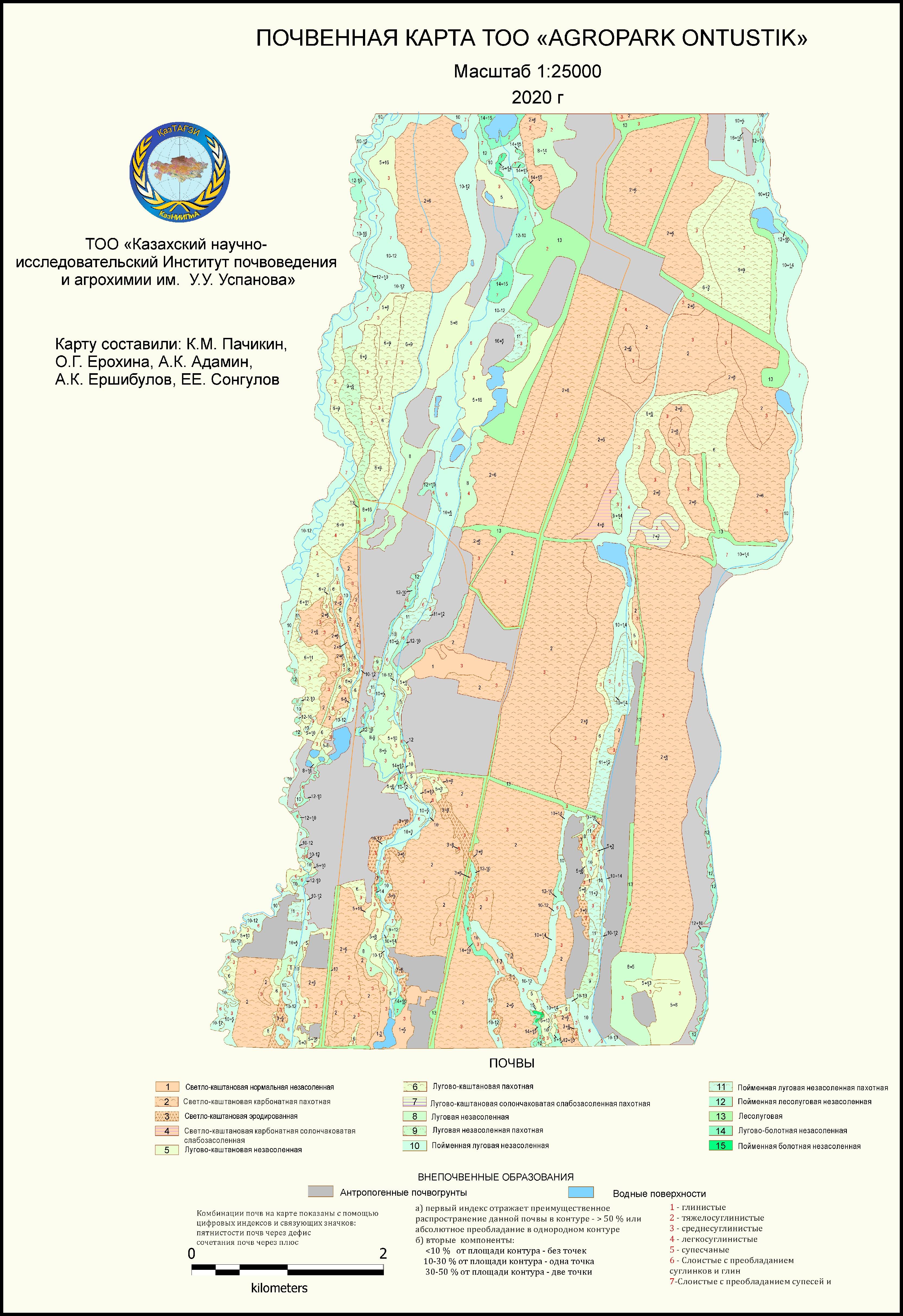
Soil map of agripark "Ontustik"
Currently, the department staff are working on three objectives of STP O.0946
"Scientific and technological support for conservation and reproduction of fertility of agricultural land", 2021-2023. (budget program 267 "Improving the availability of knowledge and scientific research" under subprogram 101 "Program-targeted financing of scientific research and activities").
Objective 2 Develop a map of horticultural lands of fruit zones in Kazakhstan
Objective 3 Create a database of wetlands and saline lands in Kazakhstan
Objective 5 Optimal use of pasture lands to ensure food security in Kazakhstan.
International projects
INTAS project “Processes of Formation of Nomadic Societies in Semirechje in the Bronze and Early Iron Ages. Ecological and archaeological researches”. No. 97-2220. 1999-2000
Project GEF - UNDP "Protection of biological diversity of the Western Tien Shan". 2001-2003
INTAS project "Geoarchaeological studies of land use and irrigation in Kazakhstan at the present and historical time". No. 0-0699. 2002-2006
INTAS project "Research on development of natural and economic resources in the Kazakhstani Aral region", No. 1072, 2002-2004.
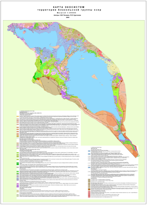
GEF-UNDP Project "Integrated Conservation of Priority Globally Significant Wetlands as a Habitat for Migratory Birds" 2004-2005.
The aim of the research: assessment of ecological state of terrestrial and aquatic ecosystems of the project area; creation of a model of spatial distribution of ecosystems (maps of ecosystems of scale 1: 200 000); development of natural-scientific justification for the expansion (creation) of SPNT of various status; selection of sites for monitoring observations and for the study of rare key species in the territory.
 |  |
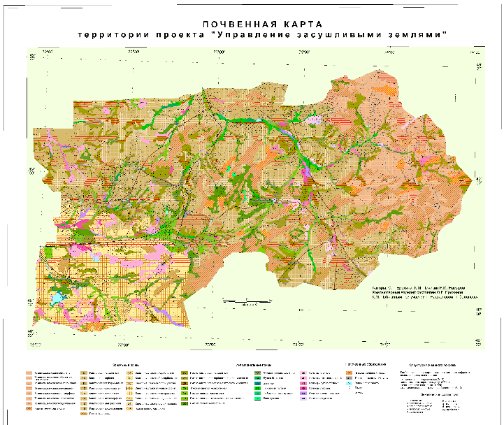
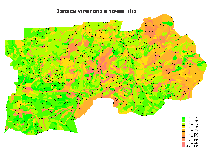
World Bank Project "Drylands Management". 2004-2009
Data on soil physicochemical properties were obtained, carbon concentration in the underground and aboveground parts of plants was determined.
A soil map of the project area at a scale of 1:200 000 was made on the basis of satellite imagery and field work. Based on it and analytical data on carbon, carbon stocks in soils of the project area were calculated and a map of carbon stocks in soils was done in absolute (t) and relative (t/ha) values. To monitor changes in carbon stocks in soils and plants, key areas were selected, where system of monitoring of changes in carbon stocks was organized.
 |  |
Contract works
1. "Big Almaty Ring Road (BAKAD)" LLP "ERM Eurasia" Agreement No. 0457363 - 01 dated May 28, 2018
2. "Comprehensive assessment of the state of environment and health of the population of the city of Kentau and adjacent settlements." Agreement No. 91 dated 09/11/2019
3. “Soil and reclamation surveys on the territory of industrial site at the facility “Reconstruction of the facilities of tailings facility of the Aktobe Copper Company LLP, to ensure operation until 2030”, contract No. AMK-162-3 / 19 dated August 13, 2019.
Among the most important soil works which were carried out by the department, it is necessary to indicate the creation of small-scale regional soil maps and Kazakhstan sheets of the State Soil Map of the USSR; large-scale soil maps of the territory of collective farms and State Land Funds during the period of development of virgin and fallow lands, medium-scale maps of administrative regions and a multicolor survey soil map of the Kazakh SSR; Regional soil maps of Semirechje and Zhambyl, South Kazakhstan regions, scale 1:500000.
A multi-volume monograph "Soils of the Kazakh SSR", a series of special maps and monographs on complex characteristics of soil surface of various natural regions were prepared and published, systematics and diagnostics of soils of the flatland territory of Kazakhstan were developed.
Soil map, map of soil geographic zoning and natural reclamation zoning of flatlands in Kazakhstan were published in the National Atlas of the Republic of Kazakhstan (M1:500000), 2010; maps “Soil Erosion and Deflation Hazard”, “Soil Erosion and Deflation Hazard”, “Soil Surface Desertification Hazard”, “Desertification Hazard” were published in the "Atlas of Natural and Technogenic Hazards and Risks of Emergencies" (M 1:500000); maps: "Soils" and "Soil degradation" in the "Atlas of Mangistau region".
Soil map at a scale of 1:8000000 and the article "Soils" were published in "The Big Atlas of History and Culture of Kazakhstan, 2008.
Based on the results of long-term researches, the staff of the department published 217 scientific papers.
 Phone:
+7 (727) 269-47-33
Phone:
+7 (727) 269-47-33
 Email: soilkz@mail.ru
 Work schedule:
8.00 - 16.30
Work schedule:
8.00 - 16.30
 RU
RU KZ
KZ EN
EN